THE IRISH PENNY JOURNAL.
| Number 9. | SATURDAY, AUGUST 29, 1840. | Volume I. |
LEIGHLIN-BRIDGE AND THE BLACK CASTLE.
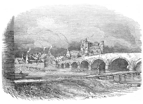
The ancient Bridge and Black Castle of Leighlin-Bridge,seated on “the goodly Barrow,” must be familiar to suchof our readers as have ever travelled on the mail-coach roadbetween Carlow and Kilkenny, for it is a scene of much picturesquebeauty, and of a character very likely to impressitself on the memory.
These are the most striking features of the town calledLeighlin-Bridge, a market and post town, situated partly inthe parish of Augha and barony of Idrone-East, and partlyin the parish of Wells and barony of Idrone-West, in thecounty of Carlow, six miles south from the town of that name,and forty-five miles S.S.W. from Dublin. This town containsabout 2000 inhabitants, and is seated on both sides of theBarrow; the bridge, which contains nine arches, dividing itinto nearly equal portions: that on the east side consists of178 houses, and that on the west of 191, being 369 houses inall. The parish church of Wells, the Roman Catholic chapel,and a national school-house, are on the Wells side of the river,as is also the ruined castle represented in our illustration.
To the erection of this castle the town owes its origin. Asa position of great military importance to the interests of thefirst Anglo-Norman settlers in Ireland, it was erected in 1181,either by the renowned Hugh de Lacy himself, or by John deClahull, or De Claville, “to whom De Lacy gave the marshallshippof all Leinster, and the land between Aghavoe andLeighlin.”
From a minute description of the remains of this castlegiven by Mr Ryan in his History and Antiquities of the Countyof Carlow, a work of much ability and research, it appearsthat it was constructed on the Norman plan, and consistedof a quadrangular enclosure, 315 feet in length and 234 feetin width, surrounded by a wall seven feet thick, with a fosseon the exterior of three sides of the enclosure, and the riveron the fourth. Of this wall the western side only is now inexistence. The keep or great tower of this fortress, representedin our sketch, is situated at the north-western angle ofthe square, and is of an oblong form, and about fifty feet inheight. It is much dilapidated; but one floor, resting on anarch, remains, to which there is an ascent by stone steps, asthere is to the top, which is completely covered over with ivy,planted by the present possessors of the castle. At the other,or south-west angle of the enclosure, are the remains of a lessertower, which is of a rotund form and of great strength, the wallsbeing ten feet thick. It is still more dilapidated than thegreat keep, and is only 24 feet high, having a flight of stepsleading to its summit.
The present name of the town, however, is derived from thebridge, which was erected in 1320 to facilitate the intercoursebetween the religious houses of old and new Leighlin, by MauriceJakis, a canon of the cathedral of Kildare, whose memoryas a bridge-builder is deservedly preserved, having also erectedthe bridges of Kilcullen and St Woolstan’s over the Liffey,[Pg 66]both of which still exist. Previously to the erection of thisbridge, the town was called New Leighlin, in contradistinctionto the original Leighlin, a town of more ancient and ecclesiasticalorigin, which was situated about two miles to the